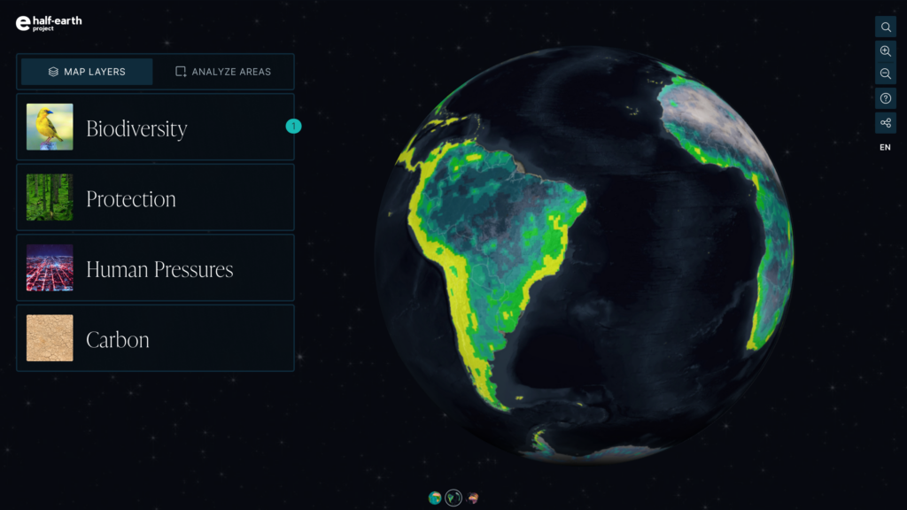
Half-Earth Project Map
Added to the Map Since Half-Earth Day 2022
· Enriched human pressure map layer, revealing: energy, transportation, urbanization, agriculture, resource extraction, and human intrusion at unprecedented resolution.
· Analyze Areas tool, which calculates species protection targets met if user-chosen area were to be conserved.
· New global marine carbon layer that adds the carbon storing power of marine environments to the terrestrial carbon layer.
· Expansion of the Species Protection Index to states and provinces, allowing for analysis of progress toward species protection goals for important areas within countries.
· Addition of data for important non-vertebrate species, including global richness and rarity layers for ants.
If we are going to save species from extinction, we need a comprehensive atlas that maps Earth’s biodiversity and is accessible to everyone. Only then will we be able to make complex decisions about how to best preserve nature for all life.
The E.O. Wilson Biodiversity Foundation’s objective is to map the location and distribution of the planet’s species at a high enough resolution to allow for on-the-ground decisions to be made at a local level. Together with our partners, we have developed the Half-Earth Project Map, a high-resolution, dynamic world map and decision-support tool that guides where place-based species conservation activities are needed the most to protect Earth’s species, including our own.
The map visualizes a global assessment of biodiversity richness and rarity at a 1–50 km scale for all terrestrial and marine vertebrates and at 1km to country scale for hundreds of thousands of invertebrate and plant species. No other open-access tool contains this resolution of global species data.
“The Half-Earth Project map is becoming a powerful tool for discovery as it combines the best of our mapping technology and global biodiversity data to help us chart a new path forward for the planet.”
Dawn Wright
Esri Chief Scientist, E.O. Wilson Biodiversity Foundation board member
Designed for a wide variety of users, the map is easy to read and navigate and can be accessed by anyone in any community. Coupled with data showing human pressures, irrecoverable carbon, and existing protected areas, the map reveals priority areas for conservation.
The Species Protection Index (SPI) measures the amount and location of currently protected land in a country and the number and location of species found both inside and outside of these protected areas. SPI ranges from 0–100, with 100 reflecting a country practicing good stewardship and promoting equitable conservation efforts within its borders. SPI is an important Essential Biodiversity Variable, an indicator for success that can be used to determine how a country is doing in any given area regarding global biodiversity stewardship and identify where additional attention is needed.
National Report Cards summarize a country’s conservation efforts. They can be used to explore conservation progress, needs, and challenges specific to each country and can help prioritize support and resources accordingly.
The Half-Earth Project Map is led by the E.O. Wilson Biodiversity Foundation in collaboration with Vizzuality, Map of Life, and Esri, with funding support from Esri, the Gordon and Betty Moore Foundation, the Burt’s Bees Foundation, and Jeff and Laurie Ubben.
EXPLORE & TAKE ACTION
EXPLORE
LEARN