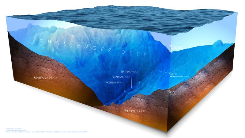
In July, a team will descend nearly 36,000 feet into the Pacific Ocean to capture images and data from the Challenger Deep, the deepest known point in the Earth’s ocean. The expedition team will include Victor Vescovo, undersea explorer and founder of the ocean research company Caladan Oceanic, as pilot and Dr. Dawn Wright as mission specialist. Dr. Wright is also a member of the board of directors of the E.O. Wilson Biodiversity Foundation. Wright recently co-authored GIS for Science Vol. 3 which features a foreword by E.O. Wilson and chapter on the Half-Earth Project effort to identify and map Earth’s species in order to protect global biodiversity.
As chief scientist of Esri, the global leader in location intelligence and geographic information system (GIS) technology, Wright will support the dive with her expertise in marine geology and the company’s geospatial technology. Through the expedition, she is also poised to become one of the few individuals—and the first Black person—to visit Challenger Deep, located within the Mariana Trench.
“I am excited to support the science and mapping goals of Victor and his Caladan Oceanic team and to further strengthen the relationship between our two organizations,” said Wright. “It is a great opportunity to perform more detailed mapping of the entirety of Challenger Deep, as well as to just fulfill my dream of visiting the location. There is still so much we don’t know about the vast majority of our own planet. This is why it is such an important scientific endeavor to understand the oceans better.”
Combining Esri and Caladan technology, Dawn and the crew are on a mission to map a part of the ocean floor using advanced sonar imaging tech. The team also will dive at the Yap and Palau trenches where Dawn will offer support as a ship crew member. Wright plans to release a series of maps and data from the dive on Esri’s ArcGIS Living Atlas of the World, the foremost collection of geographic information—including maps, applications, and data layers—from around the world. Esri is the technology partner behind The Half-Earth Project Map. One goal of making this data available is to add to the understanding of the shape and structure of this deepest part of the planet, as well as how human activity can affect such places. Maps of the seafloor are vital for everything from ship navigation to climate modeling. They provide a three-dimensional understanding of ocean volume that climate scientists need to build better models of climate change, and that conservationists need to fully assess and design marine protected areas.
Is there life in Challenger Deep?
For years it was assumed no life could exist in such harsh conditions. But even at the tremendous pressure of 16,000 psi, equivalent to the weight of 25 fully laden jumbo jets, life persists in Challenger Deep. Oceanographer Dawn Wright and expedition host Victor Vescovo expect to see deep-sea amphipods (large shrimp-like creatures).
“I hope to see, in layman’s terms, translucent or dumbo octopi, angler fish, sea cucumbers, or perhaps a snailfish, as well as the amphipods.” Says Wright, mission specialist. “We are going to be capturing everything that we see on videotape for our colleagues who specialize in deep ocean and deep trench biota to fully identify.”
Vescovo, who will host the July expedition and pilot the submersible, is also an operating partner and cofounder at Insight Equity. He has made dives to the deepest points in all five of the world’s oceans and made 12 prior visits to Challenger Deep. To do so, he commissioned Triton Submarines LLC to design and build Limiting Factor, the only vehicle that is commercially certified for unlimited depth and capable of repeatedly visiting any ocean, at any depth, at any time of year. Less well-known is that Vescovo has piloted the submersible to the five absolute deepest points in the ocean: the Challenger, Horizon, Scholl, Emden, and Sirena Deeps in the Mariana, Tonga, Kermadec, Philippine, and Mariana Trenches, respectively.
“The oceans . . . [are] 70 percent of our entire planet and, of that, 95 percent is unexplored,” Vescovo said in a 2019 TED talk. “So what we’re trying to do with our expedition is to build and prove out a submersible that can go to any point on the bottom of the planet . . . multiple times, which has never been done before. And this [submersible] . . . will open that door to exploration and [allow us to] find things that we had no idea even existed.”
During the July expedition, Vescovo and Wright will set out from Guam to test a first-of-its-kind, full-ocean-depth sonar in an attempt at finer-scale mapping of depths over six times deeper than the Grand Canyon. Caladan’s expedition team and Wright will use Esri’s GIS software to postprocess the raw sonar data and produce what they hope is the most detailed map yet of the deepest place on Earth.
To learn more visit mappingthedeep-story.hub.arcgis.com.